VATSIM
Getting Started with VATSIM: A Beginner’s Guide
VATSIM (Virtual Air Traffic Simulation Network) is a global online platform that connects flight simulation enthusiasts, allowing them to fly and control aircraft in a highly realistic environment. For pilots of Virtual Air Canada, VATSIM offers an opportunity to enhance their virtual flying experience by interacting with real-time air traffic control (ATC) and other pilots. 

Step 1: Register with VATSIM
Begin by creating a free account on the VATSIM website. After registration, you’ll receive a unique VATSIM ID and password. New members are required to complete an orientation course and pass a short exam to ensure they understand the basics of the network. This process helps maintain a high level of realism and professionalism within the community.
Step 2: Install Required Software
To connect to the VATSIM network, you’ll need:
Pilot Client: Depending on your flight simulator, install vPilot for Microsoft Flight Simulator or Prepar3D, or xPilot for X-Plane.
Flight Planning Tool: SimBrief is a popular choice for creating realistic flight plans.
Charts and Navigation: Navigraph provides up-to-date charts and navigation data.
Ensure your simulator is configured correctly and that your aircraft models are compatible with the pilot client.
Step 3: Plan Your First Flight
Start with a simple route between two airports you’re familiar with. Use SimBrief to generate a flight plan, and familiarize yourself with the departure and arrival procedures. As a Virtual Air Canada pilot, consider choosing routes that mirror real-world Air Canada operations to enhance realism.
Step 4: Connect and Communicate
Launch your flight simulator and connect to the VATSIM network using your pilot client. Before contacting ATC, listen to ongoing communications to understand the flow and phraseology. When ready, initiate contact with the appropriate controller, stating your callsign, position, and intentions.
For example: “Toronto Ground, Air Canada 123 at Gate 24, ready to taxi with information Alpha.”
Remember to follow ATC instructions promptly and maintain professionalism at all times.
Step 5: Learn and Improve
VATSIM offers various resources to help you improve your skills:
Pilot Training Programs: Participate in training sessions offered by VATSIM divisions or Virtual Air Canada to enhance your knowledge.
Community Forums: Engage with other pilots and controllers on forums to share experiences and ask questions.
Events: Join organized events to experience flying in busy airspace with full ATC coverage.
Continuous learning and practice will help you become a proficient virtual pilot on the VATSIM network.
Live Traffic & ATC Maps
SimAware
An official VATSIM live map displaying real-time aircraft positions, ATC coverage, and flight statistics. It’s an essential tool for monitoring traffic and planning flights within controlled airspace.
VATSpy
A downloadable application that provides a graphical representation of VATSIM airspace, including active controllers and pilots. It allows filtering by region and is useful for pre-flight planning.
Vattastic
A web-based map offering a comprehensive view of VATSIM traffic and ATC coverage. It includes features like airport information and METARs, aiding in situational awareness.
Flight Planning & Charts
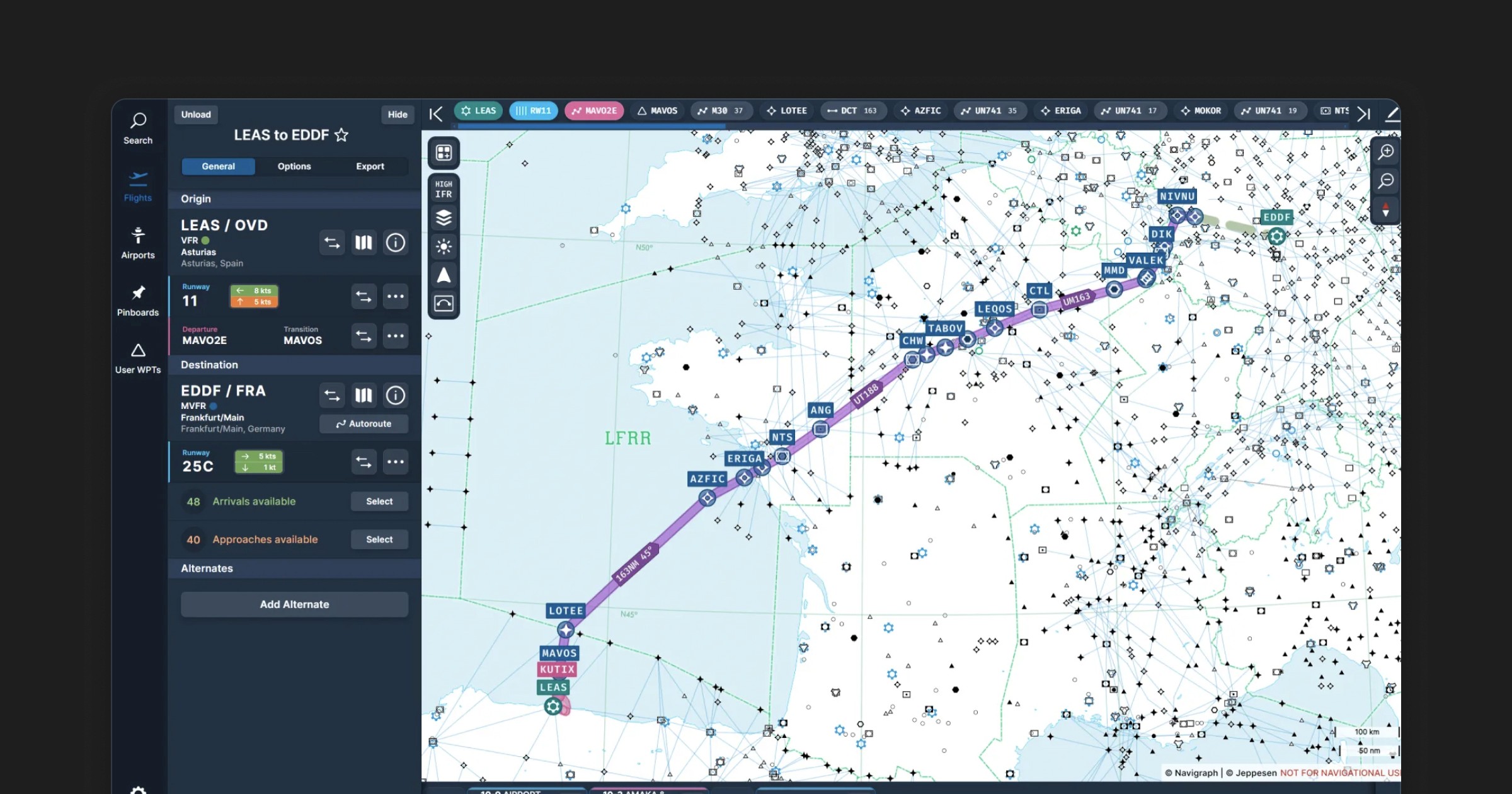
SimBrief
A free, web-based flight planning tool that generates detailed flight plans, including fuel calculations, weather forecasts, and route information. It integrates seamlessly with VATSIM for filing flight plans.
Navigraph Charts
A subscription-based service providing access to a vast library of up-to-date IFR charts, enroute maps, and airport diagrams. It now includes live VATSIM traffic overlays, enhancing situational awareness during flight planning.
ChartFox
A free alternative for accessing a wide range of aviation charts. While it may not be as comprehensive as Navigraph, it’s a valuable resource for pilots seeking chart information without a subscription.
In-Sim Tools & Utilities
VSR Toolbar
An in-sim toolbar application for Microsoft Flight Simulator that displays active VATSIM frequencies and allows for quick communication setup. It’s particularly useful for managing ATC interactions efficiently.
Airport Wx Planner
A versatile tool designed for flight tracking and chart viewing within Microsoft Flight Simulator. It offers access to over 24,000 free charts for major airports globally, alongside detailed information for pilots and air traffic control via IVAO and VATSIM networks.
Additional Tools
VATprism
A modern VATSIM map and data explorer that allows users to explore available ATC services, connected pilots, airports, and flight information regions. It’s a powerful tool for in-depth analysis of VATSIM activity.
Pilot Flight Planner VATSim
An Excel-based flight planning tool tailored for VATSIM pilots. It includes sections for ATC clearance, weather, departure/arrival information, and radio frequencies, aiding in organized and efficient flight preparation.
Integrating these tools into your VATSIM flying routine will significantly enhance your virtual aviation experience, providing you with the resources needed for realistic and efficient operations. For pilots of Virtual Air Canada, these tools are instrumental in replicating real-world procedures and maintaining high standards of virtual flight.